An Emoji For Each State
March 28, 2013
What if an emoji could be assigned to each state? Some emoji are obviously associated with certain states: 🗽 (Statue of Liberty) for New York, and 🌉 (Golden Gate Bridge) for California.
Several other states don’t have such iconic emoji, but it was easy enough associating them with an unique emoji: 🚘 (car) for Michigan, and 🎰 (slot machine) for Nevada.
(I know, some of these emoji won’t be viewable on PCs and many non-Apple mobile devices. Allow me a moment to be smug.)
(Ok, smug moment over,)
Back to emoji.
(Yes, emoji is plural for emoji.)
ANYWAY.
I was able to add a few more states to the list after doing some research: where is the Football Hall of Fame? (Answer: Ohio, which gets the 🏈 emoji.) What about Thomas Alva Edison’s lab? (New Jersey, which is hereby awarded the 💡 emoji.) My Twitter followers also helpfully supplied me with a few more ideas.
I still have a few states not yet associated with their own emoji. That’s where I need your help: can you think up the “perfect emoji” for these missing states? Can you think of better emoji for those states already awarded with (ahem, weak) emoji?
Here’s the list of states with emoji I have thus far (with some alternatives as well). I’m starting to forget why some states have the emoji they do, so I’ve helpfully supplied answers at the bottom of this post.
❄ AK
🚌 AL
🌵 AZ
🌉 CA
🏂 CO (🗻)
📃 CT (✂)
🐼 DC
1⃣ DE
🚀 FL (🍊)
🍑 GA
🌋 HI
💎 ID
💨 IL
🏁 IN
🚜 KS
🏇 KY
🎭 LA
💪 MA (🔮)
♋ MD (🐢)
🌲 ME
🚘 MI
♈ MO
🌟 MN
💰 MT
✈ NC
🌽 NE
💡 NJ
🐍 NH
👽 NM
🎰 NV
🗽 NY
🏈 OH
🔜 OK
🌹 OR
🔔 PA
🌊 RI
🌴 SC
🗿 SD
🎸 TN
⛽ TX (🗼)
🐝 UT
🚬 VA
🍁 VT
☔ WA
🍺 WI
🗻 WV
🐎 WY (😈)
(Credit to @stevenhaddox for AZ, UT, and WY. And to awesome @katiecupcake for CT, ID, ME, MN, MT, RI, SD, VT, and WV. Thank you @shannoncooley for NC and SC. @Graystorm thought of the clever emoji for MA. Wish I could remember those who also contributed earlier.)
I still need emoji for these states. Any ideas?
AR
IA
MS
NE
ND
One thing: when I list state abbreviations in alphabetical order, do I still list MA before MD even though, alphabetically, Massachusetts follows Maryland? Hmf.
Another thing: I know DC isn’t a state. Humor me, please.
Lastly, a shout out to Lisa Bonchek Adams. She blogs about her experiences “living with metastatic breast cancer, grief & loss, life, and family.” I’ve shed tears reading her searingly honest and courageous posts, and in fact I haven’t finished (and couldn’t finish) reading one of them: The Hardest Conversation. My favorite of her posts so far is the stupid things people say to those with cancer and their families.
In spite of (or perhaps because) of living with cancer, she finds the time and energy to be a mother, wife, AND social media rock star. I follow her on Twitter (she’s @adamslisa) and love how she engages with her followers.
She blogs several times a week. I haven’t blogged in a year or more. WTF, Proud Geek!? Hence this post, hopefully the first of many more.
Thank you, Lisa, for being an inspiration to me.
Some select answers (after all, I don’t want to make this TOO easy for you!):
🚌 AL – Rosa Parks in Selma, AL
📃 CT – Constitution State. Or, Cut (✂)
🐼 DC – Pandas are the main exhibit at the National Zoo
🍑 GA – The Peach State
💎 ID – The Gem State
♋ MD – Horoscope sign for Cancer, which also means crabs. And MD is for Crab lovers.
🌲 ME – The Pine Tree State
🌟 MN – The North Star State
♈ MO – Saint Louis Rams football team.
🌽 NE – The Cornhusker State
💡 NJ – Thomas Edison (inventor of the light bulb)’s lab in NJ
🐍 NH – Don’t Tread on Me snake flag
👽 NM – Roswell aliens. Enough said?
🔜 OK – The Sooner State
🌹 OR – Portland Rose Garden / Festival
🌊 RI – Ocean State
🌴 SC – Palmetto State (and a palm tree on its flag)
🗿 SD – Hoping this looks enough like Mt. Rushmore to persuade you
💰 MT – The Treasure State
🐝 UT – The Beehive State
🗻 WV – The Mountain State
😈 WY – Devils Tower (featured in the Close Encounters of the Third Kind)
Strange Maps: You CAN See Russia From Alaska
March 21, 2011
In 2008, a Sarah Palin impersonator famously said, “I can see Russia from my house.” This quote has provided fodder for countless comedians and perhaps helped propel her opponent into the White House. [Edited for accuracy]
But what many people do not realize is … Yes, Sarah, you can see Russia from your house!
That is, if you own a home on Little Diomede Island, Alaska.


As these maps of Alaska and Russia show, this tiny island is in the middle of the Bering Sea between Alaska (obviously part of the USA) and Russia, and is just 2.4 miles from its larger sibling, Big Diomede Island. However, the gulf between the two islands is actually much larger; the USA / Russia border runs between the two islands, and Big Diomede Island is owned by Russia.
Little Diomede Island, Alaska is home to less than 200 hardy residents, practically all in a small village on the west side in full view of the larger island 2.4 miles away. So, these American residents can literally see Russia from their house. Sarah was right after all!

Big Diomede Island as seen from Little Diomede Island (taken by Anant Kamath via Wikipedia)
The two islands are also separated by the International Date Line. Does that mean Sarah Palin would be seeing her future each time she gazes at Big Diomede Island, and Putin his past when he looks at Little Diomede Island? Hmm.
Legend has it that the same families settled both islands and then were torn asunder when the United States claimed one island and Russia claimed the other. And, again according to legend, births and deaths were announced by shouting across the water to the other island.
However, according to reliable (?) Wikipedia, all native residents were removed from Big Diomede Island by the Soviet government. Nowadays, only a small weather base and its staff remain on Big Diomede Island.
Strange Maps: Canada extends as far south as California
March 4, 2009
A long time ago, I heard a joke:
What do you call someone who knows three languages?
Trilingual.
What do you call someone who knows two languages?
Bilingual.
What do you call someone who knows one language?
An American.
The punchline holds true when it comes to geography. Most Americans think of Canada as cold, remote, barren. California? Ah, southern, verdant, sunny, palm trees …
Most Americans would be amazed to learn that Canada actually extends further south than the northern border of California!

Pelee Island, Ontario is the largest island in Lake Erie. Although its location is close to chilly Detroit, the lake effect gives it a milder climate than nearby mainland cities. Its climate is similar to North / South Carolina, and wine is actually grown there. It lies south of Latitude 42° N, which serves as the northern border of California. (Incidentally, the 42nd also serves as most of the northern border of Pennsylvania.)
Middle Island, Ontario is actually further south in Lake Erie than Pelee Island and is officially the southernmost point of Canada. No permanent settlements are present, however, since it is a conservation area.

“Wait a minute,” you may be saying. “These are islands. So does that mean the Canadian mainland doesn’t extend as far south as California?” Hold your Canadian Mounties horses, willya?
Point Pelee, Ontario and the hamlet of Colchester, Ontario are both on the Canadian mainland. Both also lie south of Latitude 42° N.

Consider this part of the education of us Americans so that we will no longer be the punchline of (as many) jokes. I actually didn’t know this until Guy commented on this. Thanks, Guy.
Ciao!
Strange Maps: Beebe Plain, Vermont, no, Quebec, uh …
March 3, 2009
Can you imagine crossing the street into another country just to ask for sugar? That’s what neighbors along a street in Beebe Plain, VT / Quebec can do! The USA / Canada border literally runs along Canusa Avenue and splits a small village named Beebe Plain in two.

Residents along the south side of Canusa Avenue (get the pun in the name? HA!) live in the USA, while residents of the north side live in Canada. Doesn’t look like one needs to go through an International checkpoint just to cross the street, although I wonder if there’s one just south of the village.
According to the Wikipedia entry of the Quebec side, Canusa Avenue lies entirely in Canada, and the border runs through the front lawns of the houses along the south side. So, these houses are in the USA and most of their driveways are in Canada.
The border even runs through a tool-and-die factory and at least one house. Imagine cooking a meal in one country, walking down the hall, and serving it in another country! Let’s hope that family doesn’t need to go through an International checkpoint just to get something from upstairs.

(Thanks to commentator Anman for this gem!)
Strange Maps: Just How Far North is Seattle?
August 13, 2007
Take a moment and imagine the Canadian cities of Quebec City, Montreal, and Toronto. Does your mind conjure up images of snow, heavy winter coats, car tires spinning in heavy snow, and in general being so far north that you’re within spitting image of the Arctic Circle?
Now think of Seattle. Lots of rain, no ice, very little snow (except on gorgeous Mt. Rainer), heavy on the coffee intake, lots of bridges and very few snow tires …
Would it surprise you if I told you Seattle is located more north than Toronto, Montreal, and even Quebec City? See the red line on the map below showing where Seattle is in relation to the three Canadian cities (click on the map to enlarge):
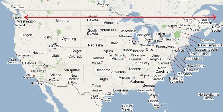
In fact, Toronto is so far south that it’s nearly on par with Detroit and Chicago. (And in fact, if you head south from Detroit, you’ll end up in Canada!)
Oh, you knew all these? Ok, grump grump, I’m not talking to YOU, I’m talking to the person behind you …
Strange Maps: Ellis Island is not quite in New York
August 9, 2007
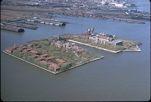 For millions of immigrants, Ellis Island was where they first stepped upon the United States, after swinging by the island upon which the Statue of Liberty stood. (Yes, the Statue of Liberty does NOT stand on Ellis Island.) And just about everyone’s grandma and grandpa knew that Ellis Island is in New York. After all, every immigrant there knew that they would be stepping into a part of New York City — onto Ellis Island — when they step off the boat.
But is Ellis Island really a part of New York? Not really.
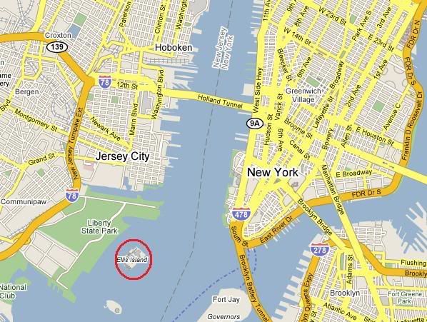
A first look at a map shows that Ellis Island is on the New Jersey side of the border.
However, from the beginning, New York had taken possession of Ellis Island, and New Jersey allowed it. In 1834, the two states entered into a compact recognizing that New York would have exclusive jurisdiction over Ellis Island.
However, beginning around 1890, the Federal government began to expand Ellis Island through landfill on all sides so that it could operate its immigration station there. Between 1890 and 1934, the Federal government poured so much landfill that the island ended up being 9/10th artificial land. That is, the original island area was only one-tenth the size of the entire “new” Ellis Island — everything else was artificial land.
New Jersey eventually filed claim to the “new” portions of Ellis Island, claiming that all of the additions were outside the boundaries of the compact and therefore a part of New Jersey. New York disagreed, and the two states actually duked it out in front of the Supreme Court in 1998. Rudy Giuliani, then Mayor of New York City during this dispute, famously claimed that his father, an immigrant from Italy, never intended to go through New Jersey.
The end result? The Supreme Court agreed with New Jersey, and said that the new additions were all part of New Jersey. If you look at the map below, the green shaded area is where the original island boundaries were — and therefore a part of the state of New York. Just approximately 5 acres were New York’s. All other portions of the island — or approximately 31 acres — were New Jersey’s. Only the Main Building was almost wholly in New York; all the other buildings were entirely or mostly in New Jersey. The two states ended up deciding to share claims to Ellis Island.

Since 1954, no immigrants have gone through Ellis Island. The entire island is Federal property anyway (although the land is shared by both states), and the Federal government operates the museum and maintains all of the buildings there.
Much ado over so little? Maybe not.
Strange Maps: Kentucky’s but maybe not?
July 9, 2007
It’s a little-known fact that there is a 17-square-mile area of Kentucky that’s totally isolated from the rest of the state. How did this happen?
The southwestern border between Tennessee and Kentucky was set to follow latitude 36°30′ — a straight horizonal line with the Mississippi River on the western end and Kentucky Lake on the eastern end. When the border was established, surveyors had incorrectly estimated that the border would meet the Mississippi River just once. However, the Mississippi River actually flows south past latitude 36°30′, then loops back north, and then loops around again and flows down past latitude 36°30′ once again.


As you can see in the picture, the end result is that this 17-mile-square portion of Kentucky — called the Kentucky Bend — is surrounded by the Mississippi River (and the State of Missouri) on three sides, and Tennessee on the fourth side. The only way to get to this portion of Kentucky is via a small Tennessee country road. Just seventeen people live there, according to the 2000 Census.

Tennessee tried to claim this land as its own, but then eventually dropped its claim by the late 1800’s. Mark Twain wrote about this area in his book, Life on the Mississippi.
I can’t imagine feeling detached and isolated like this. Even the mailing address is in Tennessee, not Kentucky. Who knows how law enforcement is set up — is it the responsibility of the sheriff from the same Kentucky county that this Bend area is part of, or from the nearest Tennessee county? Confusing. I wish the Kentucky Bend population well!
Strange Maps: Border between Canada and USA
July 6, 2007
I’ve always been fascinated by maps. Don’t know if it’s a geek thing or not. I love finding “weird” things through maps, and now with Google Maps and Yahoo Maps, the world awaits me – sort of.
A treaty sets the western half of the border between Canada and the United States at the 49th Parallel. The border follows the 49th Parallel – actually a latitude coordinate – in a straight line from roughly north of Minneapolis, MN to all the way out just past Washington State into the middle of the Strait of Juan de Fuca. Once in the Strait, the boundary loops south and then west, so that Vancouver Island stays within Canada’s boundaries. Other than that, everything north of the 49th Parallel is Canada’s, and everything south of that is the United States’.

Simple? Not really.
In several places, the ruler-straight border creates strange mapping results. At least three practical enclaves /exclaves were created — little “islands” of property belonging to the United States but almost entirely surrounded by Canada and/or accessed only through Canada. (Well, Alaska lies north of the 49th Parallel, but, well, that’s different because, well, um, it didn’t become a state till much later, um, or it wasn’t part of the United States till after …)
The first and perhaps most well-known out of these exclaves is Point Roberts. Where the USA-Canada border reaches the Strait of Juan de Fuca west of Washington State, it actually crosses one more land peninsula jutting off the mainland north of Seattle before the border actually reaches the middle of the Strait.


Point Roberts, WA is a small community of just over 1,000 people a mere 22 miles south of Vancouver, BC. Over land, the only way to reach Point Roberts is through a single road from Canada. Of course, one can take a boat from Point Roberts to the rest of Washington State. There’s only one school for kindergarten through second grade students; older students must take the bus up into Canada, around the bay, and then back into Washington State. I think after 9/11 they had to take a ferry or boat to school, but then they were able to use the bus once again once border crossings were less chaotic.
Two other exclaves are caused by the razor-straight 49th Parallel, this time at the eastern end. The 49th Parallel border runs through (and actually begins its eastern end in) the Lake of the Woods, shared by the USA (Minnesota) and Canada (Manitoba and Ontario). But the 49th Parallel border actually skims two peninsulas jutting from Canada into the Lake of the Woods. As a result, a few square miles of unpopulated, forested land is owned by the USA, even though on the map it looks like it’s part of Canada. The larger one is named Elm Point; the other is unnamed.

Interestingly enough, when viewed via Google Map’s “Map” view, it looks like the 49th Parallel international border doesn’t cut through any peninsulas in the Lake of the Woods:

But switching to the “Hybrid” view shows a different story:

Ah-ha, the two enclaves (or exclaves, whatever) clearly show up in the hybrid view.
I can’t wrap this up unless I point out one more enclave / exclave: the Northwest Angle. Many years ago, the Canadian / USA border was set at the very northwestern tip of the Lake of the Woods, and then it would run due south to the 49th Parallel then directly west. Due to ignorance of geography by the early mappers and developers of the then-young United States, it was not realized till later that the border running south from the northwestern border of the lake would set apart a good-sized chunk of land from Canada. About 140 people live there, according to the 2000 Census. For a good idea of what life’s like there, read the book, In the Lake of the Woods by Tim O’Brien.

Enough for now! More later.
Another Map: State Flowers / Trees at Risk
May 21, 2007
Another example showing how useful Google My Maps can be — this time in drawing and shading shapes and areas. And yes, this example also makes a point.
The National Wildlife Federation recently released a report, “The Gardener’s Guide to Global Warming” (PDF file). Deep in this report is a list of states (including the District of Columbia) that could see their state flowers and/or trees soon leave or become extinct because global warming has already been shifting growing zones markedly northward.
I created a Google MyMap showing each state that could lose its state flower and/or tree. Orangish yellow areas show each state that could lose its state flower; green areas show each state that could lose its state tree; and purple areas show each state that could lose BOTH its state flower and tree.
(Click on the map to see the actual Google MyMap)

Contending for the tallest building crown
May 16, 2007
Oh boy. When I heard about the Chicago Spire being planned and how it’d be the tallest building in the U.S., I then looked up the tallest buildings in the world. I had to wade through a whole slew of different types of “tallest” buildings and structures. And even for inhabitable buildings, there are different rankings depending on whether they have antennas, spires, or other architectural details on top. But, in summary …
Top Three Tallest Buildings in the World (by architectural detail):
These rankings include aesthetically-pleasing spires and other detail on top of these buildings, but not TV / radio / telephone antennas.
1. Taipei 101 – Taipei, Republic of China (Taiwan) – 1,671 ft, 101 floors
2. Petronas Tower #1 (tie) – Kuala Lumpur, Malaysia – 1,483 ft, 88 floors
2. Petronas Tower #2 (tie) – Kuala Lumpur, Malaysia – 1,483 ft, 88 floors
4. Sears Tower – Chicago, USA – 1,451 ft, 108 floorsWithin the United States, the Empire State Building is #9, at 1,250 ft and 102 floors. World Trade Center #1 and #2, if still standing today, would have been #6 and #7 (1,368 ft and 110 floors).

Top Three Tallest Buildings in the World (including antenna / pinnacle):
When including antennas and pinnacles, these rankings change:
1. Sears Tower – Chicago, USA – 1,729 ft
2. Taipei 101 – Taipei, Republic of China (Taiwan) – 1,671 ft
3. John Hancock Center – Chicago, USA – 1,500 ftThe Petronas Towers fall to #4 (tie, 1,483 ft), and the Empire State Building is next at #6 (1,472 ft). Interestingly enough, World Trade Center #1, if still standing today, would have been #2 (1,724 ft).

Top Three Tallest Buildings under construction:
Two of buildings currently under construction would be significantly higher than the tallest buildings standing today.
1. Burj Dubai – Dubai, United Arab Emirates – over 2,651 ft (final height is “secret”, might be over 3084 ft)
2. Freedom Tower – New York City, USA – 1,776 ft
3. Shanghai World Financial Center – Shanghai, China – 1,614 ft (note: this would not be as high as some of the highest buildings standing today)The Chicago Spire building is still in the planning / approval stages. It would be 2,000 feet and 150 stories — or #2 in the world and #1 in the USA. Various other buildings and towers in the planning / design stage will be much higher, even higher than the Burj Dubai building.


